


Olga Tokarczuk’s 2018 book Flights opens with a childhood memory of her first trip. Walking out of her house, across the park, down the road, through the fields, and up onto the river embankment, she writes:
I could see an undulating ribbon, a road that kept flowing outside of the frame, outside of the world. If you were lucky, you might catch sight of a boat there, one of those great flat boats gliding over the river in either direction, oblivious to the shores, to the trees, to the people who stand on the embankment, unreliable landmarks, perhaps, not worth remarking, just an audience to the boats’ own motion, so full of grace. I dreamed of working on a boat like that when I grew up - or even better, of becoming one of those boats.
The river she writes of, the Oder, starts in the Czech Republic and travels north to the Baltic Sea via Poland. It appears on a diagram a few pages later alongside 29 other principal rivers of the world. Each river is stretched into a nearly straight line so as to be easily ordered by length, which gives the reader the immediate impression that what they are looking at is actually some sort of taxonomy of jellyfish or man o’ war.
Immediately notable to me was the ink blob near the middle of the diagram, which I traced upwards with my finger until arriving at the name “Lorenzo Str”. It took me a second to place it—partially because Lorenzo didn’t immediately compute as Lawrence—but more so because, while I *knew* that the Great Lakes and St. Lawrence River constituted a contiguous waterway—I’ve seen the locks and the ships—I had never actually stopped to consider it.
In retrospect, I think that I was holding onto a lazy binary in which rivers=motion and lakes=stasis. And so, turning to Google Maps, I set about trying to more intimately acquaint myself with the singular ribbon of water that cuts across half of my home continent. I learned a lot on my journey past 38 ferry crossings, 46 bridges, and 6 tunnels, but more importantly, I found that the trip reconfigured previously discrete experiences into something cohesive; memories and impressions bound together by water from the same source.
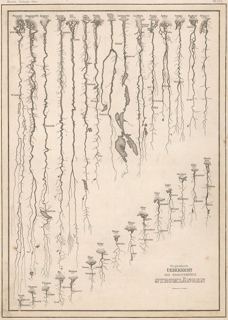
The 1852 map included in Flights. The title, “Vergleichende Übersicht der Bedeutendsten Stromlängen” translates to “World River Lengths compared in diagram format”. (Source: vividmaps).
Just two miles north of Bob Dylan’s hometown in the Iron Range of Minnesota sits a small wooded hill in the middle of a mining operation. Known as the Hill of Three Waters, this modest bump is home to the convergence of two continental divides, creating a three-way watershed that sends water north to the Arctic Ocean, south to the Gulf of Mexico, and east to the Atlantic Ocean.
When I say that it’s in the middle of a mining operation, I mean that it is literally a small forest left untouched in the middle of the apocalypse. Its preservation has been a longstanding cause of the Ojibwe people, who serve as guardians of the hill against the encroachment of the Hibbing Taconite Company. The hill is off limits for visitors and no photography is allowed, but we can get a sense of what is going on from above.

I’m fairly certain that the Hill of Three Waters is one of the two forested circles just above the center of this satellite image, between the mining road and the tailings basin. (Source: Google Maps)
If we head down the southeastern flank of the Hill of Three Waters, we’ll eventually make our way to the St. Louis River, which winds southeast past Cloquet before forming the border between Minnesota and Wisconsin and emptying into the Great Lakes near the Port of Duluth-Superior. It’s here, 2,342 miles west of the Atlantic Ocean, that we arrive at the furthest inland port in North America and quite possibly the world.
I don’t think I quite understood the breadth of inland ports in the United States until now. Fewer than half of US states are on the coast, but thanks to 19th century dredging, canal digging, and lock building in the Great Lakes/St. Lawrence River, Columbia River, Hudson River/Lake Champlain, and Mississippi/Ohio/Missouri Rivers, only eight U.S. states don’t have direct access to the sea. Many of these ports are limited to barge traffic, but not Duluth: the Great Lakes and St. Lawrence were built to receive both lake traffic and ocean-going vessels, which in turn inspired the colorful regional designation of all ships as either “Salties” or “Lakers”.

"The Last of the Free Seas" - A map of the Great Lakes made by Boris Artzbasheff published in Fortune Magazine in July 1940 (Source: Boris Artzbasheff via Reddit)
Traveling east from Duluth, we traverse the largest lake (by area) in the world. Everything I know about Lake Superior lives up the it’s name: The ice volcanoes, the prehistoric underwater forests, the old adage that Superior doesn't give up it's dead, the least visited national park outside of northern Alaska...the National Park Service says it best when they warn kayakers that Lake Superior is Not Just Another Lake Up North.
On the eastern end of Lake Superior, we arrive at the twin border cities of Sault Ste. Marie and the St. Mary’s River. Throughout the Great Lakes and St. Lawrence River, shipping channels are separated by upbound and downbound traffic. Upbound is always heading away from the Atlantic Ocean, downbound is headed towards it. So shortly after passing through the phonetically-simplified Soo Locks, we have to make a choice between sailing upbound to Chicago via Lake Michigan or to continue downbound towards Detroit on Lake Huron. There’s a lot of jargon, so here’s an illustration I made:

We continue downbound, passing through the St. Clair River, Lake Saint Clair, and the Detroit River, which collectively connect Lake Huron to Lake Erie and form an international border between Michigan and Ontario. I learned a few years ago that many Canadians have an affinity for the Journey song Don’t Stop Believin’: downtown Detroit sits at the southern end of the city right on the Detroit River, so to be a city boy born and raised in South Detroit is to be Canadian. Steve Perry admitted as much a few years ago:
"I ran the phonetics of east, west, and north, but nothing sounded as good or emotionally true to me as South Detroit. I fell in love with the line. It's only been in the last few years that I've learned that there is no South Detroit. But it doesn't matter."
In Lake Erie, we travel east from Detroit to Buffalo and the Welland Canal, an engineering marvel that cuts across the Niagara Peninsula and allows us to basically take a water staircase around Niagara Falls. I’ve driven across the peninsula once before, and I frankly find it to be a terrifying place. The whole region is crossed with locks, spillways, abandoned canals, and hydroelectric plants: nothing is built on a human scale and you immediately get the sense that the water is far more important than you are.
The fourth and current instantiation of the Welland Canal was opened in 1932 and can take ships up to 766 feet long with an 80 foot beam (width), 30 foot draft (depth below water), and 115 air draft (height above water). The Welland Canal locks serve as the size constraint for the entire system: when engineers were improving the St. Lawrence river locks in the 1950s, they opted to not expand all the way to the global “Panamax” standard set by the dimensions of the Panama Canal locks, instead establishing “Seawaymax” to match the Welland Canal. This means that any ship that can make it into Lake Ontario can sail all the way to Duluth. The inverse isn’t true, however: there are currently thirteen 1,000 foot lake freighters built on the Great Lakes for the Great Lakes: they are free to roam the four upper lakes from Duluth to Buffalo, but they can never leave.

The Panama Canal was recently expanded, establishing the “Neopanamax” ship standard. This had a ripple effect on infrastructure around the world. Here, the roadway of the Bayonne Bridge in New Jersey was raised to accommodate Neopanamax height. (Source: Craig Walenta via WikiCommons)
.jpg)
Once we’re over the Niagara Escarpment and down in lake Ontario, we pass Toronto, Rochester, and Kingston before arriving at long last to the St. Lawrence River. The name St. Lawrence came from Jacques Cartier who found refuge from a storm near the mouth of the river on Saint Lawrence’s feast day in 1535. At first, the name St. Lawrence was affixed only to the spot near where he anchored, but it soon encompassed the entire Gulf, and then the river, and then spilled over the river banks to designate mountains, countries, roads, shops, schools, and nearly anything else in need of a name. Aside from a handful of Spanish names that predate St. Lawrence by about 20 years (the first of which was Florida), St. Lawrence is the oldest European place name in the United States. The Algonquin name for the river is far more evocative for our purposes: Magtogoek means "the path that walks”.
The river forms the US/Canada border for its first hundred miles. Canadian locks are managed by the St. Lawrence Seaway Management Corporation and US locks are managed by the Saint Lawrence Seaway Development Corporation, but they coordinate operations under the really cool name "Highway H₂O". When the New York border cuts east at Cornwall, the river becomes exclusively Canadian, gains the output of the Ottawa River near Montreal, and eventually becomes tidal near Quebec City. I noticed this when visiting the city a few Januarys ago: for half the day jagged little bergs would flow downstream with the river; the other half of the day they would sort of just bob in place, neutralized by the competing forces of tide and current.
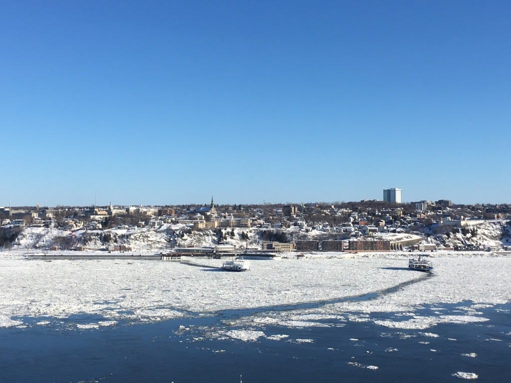
A photo I took of the ferries between Quebec City and Lévis negotiating the tides, the current, the ice, and each other.
Beyond Quebec City there are no more bridges—highways that cross the river utilize ferries. Here we enter one of the largest estuaries in the world, dotted by islands: Grosse Ile, with the most haunting monument I’ve encountered, Anticosti, with its salmon fishing and shipwrecks, and even part of the European Union. Looking at a map of the river morph into the Gulf north of the U.S. state of Maine, I’m reminded of the narrative power that borders have: to be in northern Maine is to feel at the end of something and yet—even in it’s wilderness—it remains due south of some well-maintained provincial highways dotted with billboards urging you to stop by and try the local varietal at some New Brunswick vineyard.
We end our journey as the river dissipates into the Gulf of St. Lawrence, bound to the east by Newfoundland and the Atlantic Ocean. We are closer now to Ireland than to where we started our journey in Northern Minnesota, and this proximity to Europe has made Maritime Canada a sort of base camp for European exploits ever since the first Nordic ships reached Newfoundland around 1000AD. The dead from the Titanic were spread out across Halifax graveyards, and the only known armed German ground operation in North America during World War II took place in 1943 when the crew of U-Boat 537 installed a weather station near the northern tip of Labrador: it remained undiscovered until 1977.

Left: In Halifax, the grave of an Irish coal trimmer on the Titanic named Joseph Dawson. Labeled “J. Dawson”, many fans of the movie Titanic now leave flowers at his grave due to the similarity to Leonardo DiCaprio’s fictional character Jack Dawson. (Source: Stacey). Right: The German Weather Station Kurt in Labrador upon rediscovery in 1977. In an effort to disguise it as an Allied station, the Germans scattered American cigarettes nearby and made a sign that read “Canadian Meteor Service'', a name that they made up. It took another four years after its discovery to confirm that it was in fact German. (Source: Insh).
When I think about Maritime Canada as being in Europe’s backyard, there is one story that stands out above the rest. Late in the first World War on December 6, 1917, a French cargo ship laden with high explosives collided with a Norwegian relief vessel in Halifax Harbor. The collision created the largest human-made explosion in world history (a title it would sadly not hold for very long) and liquidated city blocks. The city of Halifax was devastated, and Boston quickly responded by sending nurses and doctors to help. As a thank you, Halifax sent Boston a Christmas tree the following winter, a tradition that they revived in 1971 and have continued ever since. I knew none of this when I visited Halifax in 2016 and was warmly greeted by nearly every Nova Scotian I interacted with who learned that I was from Boston. I’m retroactively embarrassed by my ignorance now that I understand the pride and logistics that go into the tradition. A few excerpts from The Boston Christmas Tree on Wikipedia:
The Christmas Tree Extension Specialist whose responsibility it is to select a tree is "always looking" for trees, and keeps a list of trees for years...Owners often would not normally "have dreamed of cutting down the big spruce Grandpa planted" but will "gladly part with it" when told it is going to Boston...It takes two men a day and a half to prepare the tree to be cut down...The tree travels over 750 miles (1,200 km) to Boston, with a stop at the Grand Parade in Halifax for a public send-off ceremony...People stand on the sides of roads and on highway overpasses to get a glimpse of the tree and to take pictures…"It never ceases to amaze me how excited people get about it every year. The whole province gets excited about the tree..."

A 2013 photo of students at St Stephen’s Elementary School in Halifax, Nova Scotia, cheering as the tree passes by on its way to Boston. Unclear as to why there are people in costume. (Source: Nova Scotia Department of Natural Resources via Boston Globe)
I learned all of this just in time for the 100th anniversary of the explosion, and so in December 2017 I biked over to Boston Common for the annual Christmas tree lighting. I couldn’t have anticipated the pomp awaiting me: there were Nova Scotian flags everywhere, dancers and singers from across the Province, and well-represented Maritime business interests. A CBC article had recently come out questioning the cost of the whole send-a-tree-to-Boston thing, but never mind that for now because the 53 foot white spruce came from Bob and Marion Campbell on Cape Breton, and it was a thing of beauty. I don’t think I’ll ever forget the sight of Marty Walsh standing up there on a freezing cold stage crowded between the Mayor of Halifax, the Premier of Nova Scotia, and Santa Claus, red in the face, his breath condensating in the cold winter air, screaming “here’s to the next hundred years!” We sang a few more songs, and then everyone went home.
Thanks for reading,
-- Grif